

Top 7 Urban Planning Mapping Drones in the USA for 2026
Published on Thursday, February 26, 2026
Urban planning mapping drones are revolutionizing how cities are developed and managed in the USA. These professional surveying drones deliver precise aerial views, high-resolution imagery, and geospatial data that improve decision making for planners, architects, and municipal teams. As urban populations grow and cities face pressures for efficient land use, transportation planning, and climate resilience, mapping drones provide fast, repeatable, and cost-effective ways to produce orthomosaics, digital surface models, and LiDAR surveys. Buyers in this market prioritize accuracy (RTK/PPK), sensor flexibility (RGB, multispectral, LiDAR), flight reliability, regulatory compliance, and smooth GIS integration, making these platforms especially appealing to municipal programs, private planning firms, and infrastructure project teams across the USA.
Top Picks Summary
DJI Matrice 350 RTK
The DJI Matrice 350 RTK is a reliable, enterprise-grade multirotor that pairs integrated RTK positioning with long endurance and a broad payload ecosystem, making it a practical workhorse for urban planning mapping missions. Its mature software stack, global support network and strong price-performance balance make it easier to deploy than higher-cost specialty platforms like the Freefly Astro, while providing more payload options than many autonomy-focused systems such as the Skydio X10 and competitive cost-per-flight compared with the Autel EVO II Pro V3 RTK; for very large area coverage planners may still prefer a fixed-wing eBee X.

Where to buy DJI Matrice 350 RTK in USA: the trusted retailers we track in this market, with the best price we have observed at each. Prices are checked regularly and can change, and the retailer confirms the final price at checkout.
We may earn a commission on purchases. It never affects our rankings.
$13,000 – $20,000
DJI Mavic 3 Enterprise
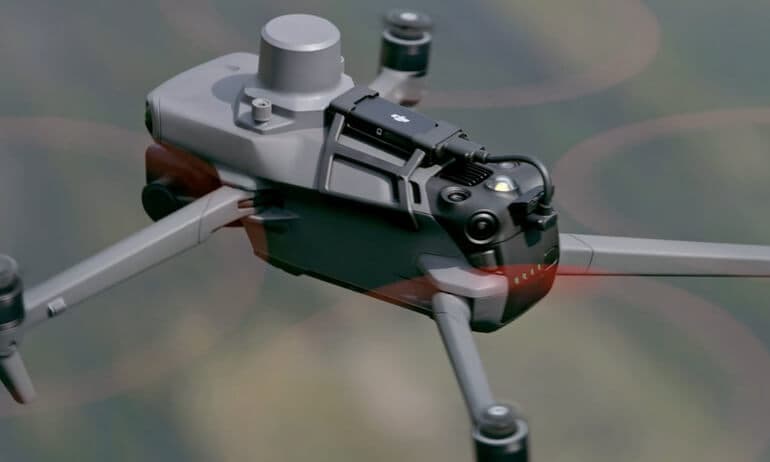
The DJI Mavic 3 Enterprise stands out in the urban planning mapping drone market with its impressive dual-camera system, featuring a 48MP wide-angle camera and a 12MP telephoto lens. Its advanced obstacle sensing technology ensures safety and efficient navigation in urban environments, making it ideal for mapping projects. The extended flight time and robust data collection capabilities provide professionals with a competitive edge in precision and productivity.
Where to buy DJI Mavic 3 Enterprise in USA: the trusted retailers we track in this market, with the best price we have observed at each. Prices are checked regularly and can change, and the retailer confirms the final price at checkout.
We may earn a commission on purchases. It never affects our rankings.
$6,599.00USD
Autel Robotics EVO II Pro
The Autel EVO II Pro V3 RTK delivers high-resolution imaging with optional RTK at a competitive upfront price, giving urban planners an attractive balance between image quality and acquisition cost for photogrammetric surveys. It undercuts some premium enterprise rigs on capital expense and can produce comparable mapping deliverables to the Matrice 350 RTK for many projects, though it sacrifices some payload modularity and the breadth of enterprise services offered by DJI and Freefly.

Skydio X10
The Skydio X10 emphasizes industry-leading autonomy and obstacle avoidance, enabling repeatable mapping and inspection flights in dense urban environments with reduced pilot workload and lower operational risk. Its autonomous capabilities can lower labor costs and improve mission safety compared with manual multirotors like the Matrice or Autel, but it has less payload modularity than Freefly Astro and does not match the areal efficiency of the fixed-wing senseFly eBee X for large-scale surveys.

Where to buy Skydio X10 in USA: the trusted retailers we track in this market, with the best price we have observed at each. Prices are checked regularly and can change, and the retailer confirms the final price at checkout.
We may earn a commission on purchases. It never affects our rankings.
$14,000 – $30,000
Parrot Anafi USA
The Parrot ANAFI USA is built specifically for professionals in urban planning and mapping, featuring dual 32x zoom and thermal imaging capabilities. Its lightweight and portable design makes it easy to transport, while the high-resolution imaging ensures accurate data collection. Moreover, its advanced security features make it suitable for sensitive urban planning projects, providing users with peace of mind alongside sophisticated mapping solutions.

Freefly Astro
The Freefly Astro is a premium, highly customizable platform designed to carry heavy or multiple sensors—ideal when LiDAR, thermal and high-resolution photogrammetry must be combined for complex urban mapping projects. Its technical flexibility and build quality support advanced survey configurations that justify a higher capital outlay versus the Matrice and Autel, but routine neighborhood-scale mapping will often be more cost-effective with the eBee X or standard multirotors.

senseFly eBee X
The senseFly eBee X is a fixed-wing mapping specialist offering long endurance and rapid area coverage, delivering survey-grade orthomosaics and DEMs with low operational cost per hectare—well suited to city-wide planning and large-area topographic surveys. While it lacks the vertical agility and close-proximity inspection capability of multirotors like the Skydio X10 and Matrice series, its superior areal throughput and low sortie count make it the most cost-effective option for large urban mapping programs.

Where to buy senseFly eBee X in USA: the trusted retailers we track in this market, with the best price we have observed at each. Prices are checked regularly and can change, and the retailer confirms the final price at checkout.
We may earn a commission on purchases. It never affects our rankings.
$15,000 – $30,000
Research and evidence supporting mapping drones
Scientific research, university case studies, and U.S. pilot programs demonstrate that drone-based mapping can reliably supplement or replace parts of traditional surveying workflows. Studies and municipal pilots highlight benefits in accuracy, speed, safety, and cost when drones are paired with proper processing workflows and quality control. For planners new to drone mapping, the strongest evidence shows that combining photogrammetry or LiDAR sensors with RTK/PPK positioning improves geospatial accuracy to levels useful for detailed urban analysis, asset inventories, and change detection.
Accuracy and positioning: Research and industry validations show that RTK and PPK workflows significantly reduce horizontal and vertical positioning errors compared with non-corrected GNSS, making drone outputs suitable for many planning applications.
Time and cost savings: Case studies from U.S. municipalities report faster site coverage and lower operational cost per acre versus conventional ground surveys for neighborhood- to district-scale mapping.
Safety and accessibility: Drones reduce the need for surveyors to access hazardous or congested sites, improving field safety while enabling frequent revisits for monitoring.
Data richness: Combining RGB, multispectral, thermal, and LiDAR data supports a range of analyses from land use classification to vegetation health and flood modeling.
Standards and integration: Best practices and FAA guidance, together with GIS-compatible deliverables (orthomosaics, DSM/DTM, point clouds), facilitate integration with existing planning and asset management systems.
Pilot program results: Multiple U.S. cities and universities have published pilot results showing that structured drone programs can scale to cover routine mapping needs while conforming to regulatory and privacy expectations.
Frequently Asked Questions
Which drone should urban planners buy for RTK mapping?
Choose the DJI Matrice 350 RTK: it has integrated RTK positioning, supports Zenmuse H20/H20T and third‑party LiDARs, and offers up to ~55 minutes flight time depending on payload, with a 4.8 average rating.
What exact camera and imaging specs does DJI Mavic 3 Enterprise?
The DJI Mavic 3 Enterprise uses a dual-camera system with a 48MP wide-angle camera plus a 12MP telephoto lens, includes advanced obstacle avoidance, and has a 30 minutes flight time with a 4.8 average rating.
How does Autel EVO II Pro V3 RTK compare price-wise?
The Autel EVO II Pro V3 RTK costs $6,599.00 USDwhile the DJI Mavic 3 Enterprise is $6,599.00 USD; Autel includes a 1‑inch sensor, built‑in RTK module for centimeter‑level positioning, and roughly 40–45 minute flight time.
Is DJI Matrice 350 RTK weatherproof for outdoor surveys?
Yes—the DJI Matrice 350 RTK has IP55 weather resistance, comes as an integrated RTK multirotor, supports Zenmuse H20/H20T and third‑party LiDARs, and is rated 4.7 on average.
Conclusion
This list highlights seven mapping drones well suited to urban planning needs in the USA: DJI Matrice 350 RTK, DJI Mavic 3 Enterprise, Autel EVO II Pro V3 RTK, Skydio X10, Parrot ANAFI USA, Freefly Astro, and senseFly eBee X. Each platform has strengths for mapping workflows: the DJI Matrice 350 RTK is the best overall choice for most professional urban planning teams thanks to its payload flexibility, RTK accuracy, flight reliability, and mature ecosystem. The DJI Mavic 3 Enterprise and Autel EVO II Pro V3 RTK offer excellent sensor performance and portability; Skydio X10 excels in obstacle-aware autonomous flights; Parrot ANAFI USA is lightweight with thermal options; Freefly Astro targets high-end cinema and precision payloads; and the senseFly eBee X is a fixed-wing leader for large-area mapping. We hope you found what you were looking for. You can refine or expand your search using the site search to compare sensors, flight time, payloads, or FAA compliance options.