

Top 5 Agricultural Mapping Drones in the USA, 2026
Published on Monday, February 2, 2026
Agricultural mapping drones are specifically designed to aid farmers in monitoring crop health, improving yields, and optimizing resources. With the increasing demand for sustainable agriculture and precision farming in the USA, these drones have become an essential tool for agronomists and farmers alike. Equipped with advanced sensors, they provide detailed aerial data that helps in analyzing crop conditions, identifying pests, and planning effective resource management. As farmers increasingly seek technology to enhance productivity and efficiency, the popularity of agricultural mapping drones continues to soar across the American agricultural landscape.
Top Picks Summary
DJI Mavic 3 Enterprise
The DJI Mavic 3 Multispectral is a state-of-the-art drone designed specifically for agricultural and environmental monitoring. It features dual cameras with a multispectral sensor that captures RGB and multispectral data simultaneously, enabling precise crop analysis and health assessments. This drone stands out for its extended flight time and robust software integration, making it a favorite among precision farming professionals. Its lightweight design and high-level automation facilitate easy deployment and data collection.
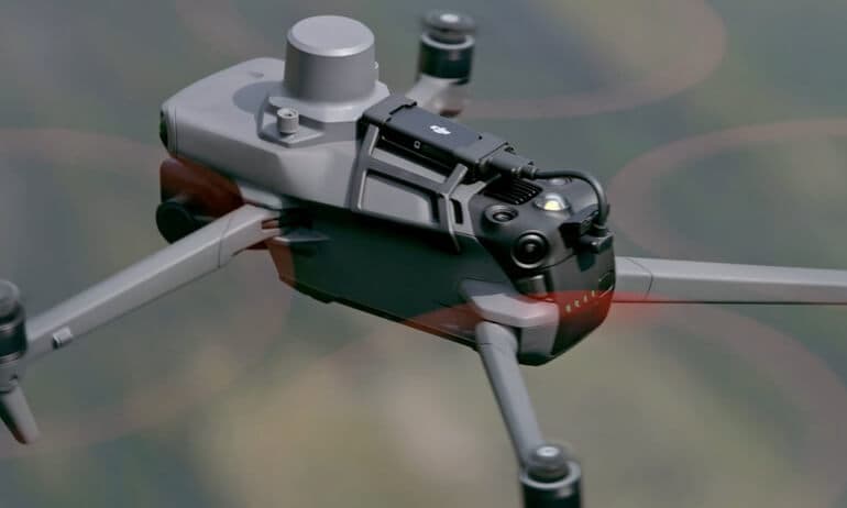
Where to buy DJI Mavic 3 Enterprise in USA: the trusted retailers we track in this market, with the best price we have observed at each. Prices are checked regularly and can change, and the retailer confirms the final price at checkout.
We may earn a commission on purchases. It never affects our rankings.
$6,599.00USD
senseFly eBee Ag
The senseFly eBee Ag is a high-performance fixed-wing drone perfect for agricultural mapping and survey needs. With its ability to cover vast areas in a single flight, it offers efficiency that outperforms many multi-rotor drones on the market. Its precision mapping capabilities, combined with various sensor options, allow for high-resolution aerial images and accurate analysis of crop health. The eBee Ag is a go-to solution for agriculture professionals seeking reliable and comprehensive aerial surveying.

Where to buy senseFly eBee Ag in USA: the trusted retailers we track in this market, with the best price we have observed at each. Prices are checked regularly and can change, and the retailer confirms the final price at checkout.
We may earn a commission on purchases. It never affects our rankings.
$15,000 – $20,000
Parrot Anafi USA
The Parrot ANAFI Ai is a cutting-edge drone equipped with advanced AI and 4G connectivity, bringing unparalleled data capture capabilities to agricultural monitoring. Its unique camera setup enables 32x zoom and wide-angle views, allowing farmers to analyze crops with incredible detail while covering large fields efficiently. The ANAFI Ai stands out due to its compact design, making it easily portable, and its comprehensive cloud solutions for data processing and sharing. This drone is an innovative option for professionals looking to enhance their agricultural workflows.

Quantix Mapper
The Quantix Mapper is an all-in-one drone that combines the capabilities of fully autonomous flight with intelligent mapping and analysis. It features a hybrid design that allows for vertical take-off and landing, making it easy to deploy in the field. Its innovative sensor technology captures high-resolution imagery and multispectral data, providing vital insights into crop health. This drone stands out for its user-friendly interface and exceptional data processing speed, making it ideal for modern agricultural practices.

Where to buy Quantix Mapper in USA: the trusted retailers we track in this market, with the best price we have observed at each. Prices are checked regularly and can change, and the retailer confirms the final price at checkout.
We may earn a commission on purchases. It never affects our rankings.
$5,000 – $8,000
DJI Agras T30
The DJI Agras T30 is an advanced agricultural drone specifically built for precision spraying and crop protection. With its larger payload capacity and effective delivery system, it can cover more ground in less time, significantly enhancing farming efficiency. The T30’s robust design and smart flight modes allow for precise application of fertilizers and pesticides, ensuring uniform coverage and minimizing waste. Its sophisticated AI-powered features provide farmers with the tools to optimize their agricultural operations effectively.
Where to buy DJI Agras T30 in USA: the trusted retailers we track in this market, with the best price we have observed at each. Prices are checked regularly and can change, and the retailer confirms the final price at checkout.
We may earn a commission on purchases. It never affects our rankings.
$12,000 – $15,000
What makes agricultural mapping drones the best in their category is their ability to capture high-resolution images and collect multispectral data for in-depth analysis of crop conditions.
Benefits of Agricultural Mapping Drones
Agricultural mapping drones provide insights that help farmers make informed decisions regarding their crops. Here are key advantages:
Enhanced Crop Monitoring: Drones allow for real-time monitoring of crops, giving farmers timely information about plant health.
Detailed Aerial Imagery: High-resolution images captured from drones can reveal crucial crop conditions not visible from the ground.
Precision Agriculture: Data collected from drones enables precision farming, allowing farmers to apply resources more efficiently and sustainably.
Pest and Disease Detection: Early identification of pest infestations and diseases helps in minimizing crop loss and optimizing treatment plans.
Soil Analysis: Drones can assist in analyzing soil conditions, leading to better understanding and management of soil health for improved yields.
Cost Efficiency: By using drones, farmers can reduce labor costs and improve their planning capabilities, resulting in higher profitability.
Frequently Asked Questions
Which drone should I pick for farm crop health mapping?
Choose the DJI Mavic 3 Multispectral if you want crop health insights from dual-camera multispectral imaging that captures RGB and multispectral data simultaneously; it’s rated 4.8.
Does the Parrot ANAFI Ai have zoom and what is it?
Yes—the Parrot ANAFI Ai includes a 4K HDR camera with 32x zoom, plus AI-powered flight planning; it’s rated 4.3.
How does Parrot ANAFI Ai pricing compare for mapping?
The Parrot ANAFI Ai lists at $1,297.99 and includes a 4K HDR camera with 32x zoom and AI-powered flight planning; it’s rated 4.3.
Which drone covers the most area per flight for mapping?
The senseFly eBee Ag covers up to 50 mi² in a single flight, making it ideal for large agricultural mapping; it’s rated 4.5.
Conclusion
In conclusion, agricultural mapping drones represent a crucial advancement in farming technology in the USA, helping farmers to adapt to the needs of sustainable agriculture. We hope you found the information beneficial. For more specific inquiries, feel free to use the search bar to explore further.