

Topographic Mapping Drones: Top 5 Picks for USA in 2025
Published on Wednesday, April 2, 2025
Topographic mapping drones are revolutionizing the way we gather and analyze terrain data. These advanced aerial devices provide critical elevation and contour information necessary for various applications, ranging from engineering projects to landscape analysis. Consumers in the USA are increasingly opting for drones due to their accuracy, efficiency, and ability to cover vast areas in a fraction of the time required by traditional surveying methods. With the growing demand for precise geographical data in sectors such as construction, environmental science, and agriculture, choosing the right topographic mapping drone is essential for professionals to achieve their goals.
Top Picks Summary
DJI Mavic 3 Enterprise
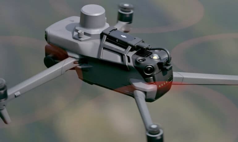
The DJI Mavic 3 Enterprise Advanced is a top-tier commercial drone that combines high-resolution imaging capabilities with advanced features designed for professional applications. What sets it apart is its dual-camera system that offers both thermal imaging and high-resolution RGB capabilities, making it ideal for surveying, inspection, and search-and-rescue missions. With a flight time of up to 45 minutes and up to 10 mi of transmission range, this drone ensures you can cover vast areas without interruptions. Its compact design and robust features make it a favorite among both experienced and novice pilots.
Where to buy DJI Mavic 3 Enterprise in USA: the trusted retailers we track in this market, with the best price we have observed at each. Prices are checked regularly and can change, and the retailer confirms the final price at checkout.
We may earn a commission on purchases. It never affects our rankings.
$6,599.00USD
senseFly eBee Geo
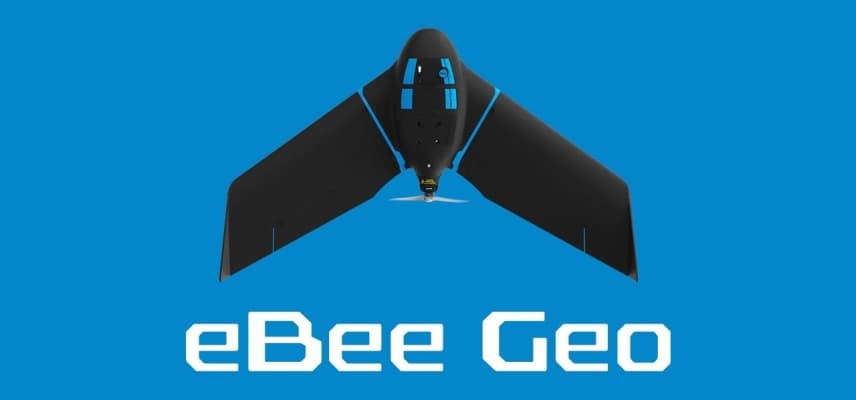
The senseFly eBee Geo is a leading mapping drone that offers unparalleled ease of use and efficiency for aerial surveying and photogrammetry. It stands out due to its ability to cover large areas quickly with high precision, thanks to its fixed-wing design which provides extended flight times. Integrating with professional-grade photogrammetry software allows users to generate detailed maps with high-resolution imagery effortlessly. The eBee Geo is designed for professionals who require reliable performance and accuracy in their mapping tasks.
Where to buy senseFly eBee Geo in USA: the trusted retailers we track in this market, with the best price we have observed at each. Prices are checked regularly and can change, and the retailer confirms the final price at checkout.
We may earn a commission on purchases. It never affects our rankings.
$37,000 – $45,000
WingtraOne GEN II
The WingtraOne GEN II is a market leader in the drone mapping sector, offering a unique vertical takeoff and landing (VTOL) design that combines the efficiency of fixed-wing flight with the versatility of quadcopters. It is distinguished by its ability to capture both high-accuracy mapping data and high-resolution imagery over extensive areas in a single flight. This drone is equipped with powerful sensors which make it an ideal choice for surveying, agricultural management, and construction site monitoring. With durable build quality and ease of use, it stands out among competitors in aerial mapping solutions.

Where to buy WingtraOne GEN II in USA: the trusted retailers we track in this market, with the best price we have observed at each. Prices are checked regularly and can change, and the retailer confirms the final price at checkout.
We may earn a commission on purchases. It never affects our rankings.
$20,000 – $25,000
Autel Robotics EVO II Pro
The Autel Robotics EVO II Pro RTK is a feature-rich drone that exceeds expectations in both image quality and precision, making it a favorite among professionals in various industries. What sets it apart is its 1-inch sensor that captures stunning 6K video and high-resolution photographs, coupled with RTK capabilities that ensure centimeter-level accuracy. This drone features a robust design suitable for both indoor and outdoor applications and offers a variety of intelligent flight modes. Its competitive price point in the high-end drone market makes it a compelling choice for serious drone enthusiasts and professionals alike.

Vespera V-Line
The Vespera V-Line is a cutting-edge drone uniquely engineered for astronomy enthusiasts, allowing users to explore the night sky with unprecedented convenience and mobility. Its standout feature is the integration of advanced imaging technology that facilitates astrophotography with ease, enabling users to capture stunning cosmic images without complex setup processes. Designed for portability, it is lightweight and compact, making it easy to transport to remote viewing locations. This innovative drone merges technology with astronomy, providing an exceptional tool for both amateurs and experienced stargazers.

High-precision elevation data and advanced photogrammetry techniques for detailed terrain mapping.
Understanding Topographic Mapping Drones
Topographic mapping drones are equipped with advanced sensors and technology that enhance the accuracy and efficiency of terrain data collection. Here’s what you need to know about them:
Enhanced Data Accuracy: Research shows that drones can achieve accuracy within centimeters, making them ideal for detailed topographic mapping.
Rapid Area Coverage: Aerial drones can survey hundreds of acres in a day, significantly reducing the time needed for traditional land surveying.
Cost-Effective Solutions: Studies indicate that using drones can save up to 30% on project costs compared to conventional surveying methods due to decreased manpower and time.
High-Resolution Imaging: Equipped with advanced cameras and sensors, drones provide high-resolution images that facilitate better analysis and decision-making.
Multispectral Capability: Drones can gather multispectral data which is useful for agricultural monitoring and environmental analysis, allowing for a more comprehensive data set.
Real-Time Data Processing: Many topographic mapping drones offer real-time data transmission, enabling immediate decision-making for projects in the field.
Frequently Asked Questions
Which drone should I pick for survey-grade topographic mapping?
Choose the senseFly eBee Geo for survey-grade topographic mapping because it’s “Highly reliable for survey-grade mapping” and has an average rating of 4.6.
What imaging or surveying capability does DJI Mavic 3 Enterprise Advanced have?
The DJI Mavic 3 Enterprise Advanced includes “Robust RTK accuracy” as a key feature, with an average rating of 4.8.
How does the DJI Mavic 3 Enterprise Advanced price compare for value?
The DJI Mavic 3 Enterprise Advanced costs $6,599.00 USDand includes “30% longer flight time” plus “Robust RTK accuracy,” while averaging 4.8 stars.
Does the WingtraOne GEN II’s design help for takeoff and landing?
Yes—the WingtraOne GEN II has vertical take-off and landing (VTOL), and it averages a 4.7 rating.
Conclusion
In summary, the landscape of topographic mapping drones in the United States for 2025 offers various options tailored for professional needs. We hope you found this guide helpful in navigating your choices. If you’re looking for anything more specific, feel free to use the search bar.