

Best 3D Mapping Drones in USA 2026 — Top 7 Industrial Picks
Published on Thursday, February 26, 2026
3D mapping drones are transforming how professionals capture and analyze the built and natural environment. These advanced unmanned aerial vehicles produce realistic three dimensional models of terrain, infrastructure, and vegetation using a combination of photogrammetry, LiDAR, multispectral sensors, and onboard GNSS/RTK. In the USA market through 2026, demand has risen from architecture, construction, surveying, mining, agriculture, and environmental monitoring because these systems deliver faster data acquisition, centimeter level accuracy, and safer inspections than many traditional methods. Consumers and organizations prefer 3D mapping drones for their ability to compress weeks of ground work into hours, integrate with GIS and CAD workflows, and reduce field risk while improving reporting and regulatory compliance.
Top Picks Summary
DJI Mavic 3 Enterprise
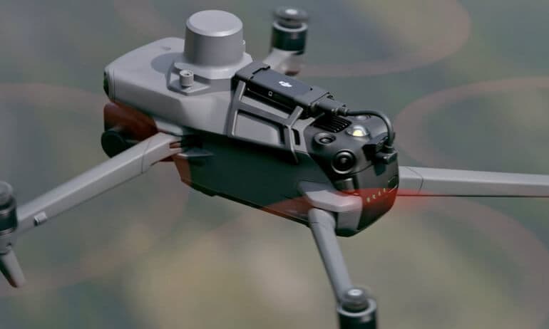
The DJI Mavic 3 Enterprise stands out with its advanced dual-camera system that includes both a 12MP wide-angle and a 48MP telephoto lens. This drone is designed for professional use, providing high-resolution imagery and enhanced thermal capabilities, making it perfect for industries such as surveying and mapping. Its flight time of up to 45 minutes allows for extended missions without frequent recharging. Additionally, the drone features obstacle avoidance technology and intelligent flight modes, ensuring safe and efficient operations.
Where to buy DJI Mavic 3 Enterprise in USA: the trusted retailers we track in this market, with the best price we have observed at each. Prices are checked regularly and can change, and the retailer confirms the final price at checkout.
We may earn a commission on purchases. It never affects our rankings.
$6,599.00USD
DJI Matrice 350 RTK
The Matrice 350 RTK is positioned as the market leader for 3D mapping thanks to its built-in RTK accuracy, broad payload compatibility (including Zenmuse LiDAR and high-resolution photogrammetry cameras), and mature enterprise software and support ecosystem. Compared with the smaller Autel EVO II Pro V3 and agile Skydio X10, the M350 RTK offers a better balance of scalability and total cost of ownership for large projects, while undercutting ultra-specialized platforms like Freefly on price for comparable survey workflows.

Where to buy DJI Matrice 350 RTK in USA: the trusted retailers we track in this market, with the best price we have observed at each. Prices are checked regularly and can change, and the retailer confirms the final price at checkout.
We may earn a commission on purchases. It never affects our rankings.
$13,000 – $18,000
Autel Robotics EVO II Pro V3
The EVO II Pro V3 earns its place as a best-in-class photogrammetry workhorse by combining a high-resolution imaging sensor, long flight times, and a competitive price point that makes precise 3D mapping accessible to smaller survey teams. It trades the Matrice's multi-payload flexibility for lower upfront cost and simpler operations, making it an attractive financial choice for projects that prioritize high-detail aerial imagery over heavy LiDAR payloads or enterprise-level fleet management.

Skydio X10
The Skydio X10 stands out for autonomous flight and obstacle avoidance, reducing pilot workload and increasing data-collection consistency in complex urban or infrastructure environments where manual flying is risky or slow. Technically it excels where the Matrice or senseFly fixed-wings require more manual planning, and although its acquisition cost can be higher than entry-level photogrammetry drones, the operational savings from autonomy and reduced re-flights often offset that difference on constrained-site projects.

Where to buy Skydio X10 in USA: the trusted retailers we track in this market, with the best price we have observed at each. Prices are checked regularly and can change, and the retailer confirms the final price at checkout.
We may earn a commission on purchases. It never affects our rankings.
$14,000 – $28,000
Parrot ANAFI Ai
The Parrot ANAFI Ai is a revolutionary drone that utilizes 4G connectivity, enabling users to transmit high-quality live video and access aerial data seamlessly, regardless of distance. It boasts a unique 32MP camera with HDR capabilities and a 180-degree tilt gimbal that allows for versatile shooting angles. Designed for professionals, this drone's lightweight build and compact design make it easy to transport. Its emphasis on security and data protection sets it apart from competitors in its class.

Where to buy Parrot ANAFI Ai in USA: the trusted retailers we track in this market, with the best price we have observed at each. Prices are checked regularly and can change, and the retailer confirms the final price at checkout.
We may earn a commission on purchases. It never affects our rankings.
$4,000 – $5,000
senseFly eBee X
The eBee X is the market leader for large-area 3D mapping thanks to its fixed-wing endurance, rapid coverage per flight, and efficient cost-per-hectare performance, making it ideal for cadastral, agriculture and mining surveys. While less nimble than multirotor systems like the Matrice or Skydio for vertical or confined-site work, the eBee X delivers unmatched efficiency for wide-area orthomosaic and DSM production, often lowering overall project costs for large survey footprints.

Where to buy senseFly eBee X in USA: the trusted retailers we track in this market, with the best price we have observed at each. Prices are checked regularly and can change, and the retailer confirms the final price at checkout.
We may earn a commission on purchases. It never affects our rankings.
$12,000 – $30,000
Freefly Astro
The Freefly Astro is positioned as a high-end 3D mapping platform focused on heavy-sensor integration, precision stabilization, and high-speed corridor mapping for industrial clients that require combined LiDAR and photogrammetry payloads. It commands a premium price compared with the Matrice or Autel offerings but provides technical advantages—modular payload bays and advanced stabilization—that justify the investment for utility, inspection, and infrastructure projects where sensor fidelity and repeatability are paramount.

Research and Evidence Supporting 3D Mapping Drones
A growing body of scientific research and industry studies supports the accuracy, efficiency, and safety benefits of drone based 3D mapping. Peer reviewed papers and technical reports compare photogrammetry and LiDAR workflows, evaluate error budgets for RTK and PPK positioning, and quantify time and cost savings on real world projects. Research also highlights how improved sensor fusion and machine learning reduce manual processing time and enable automated feature extraction for change detection, volumetrics, and asset management.
Accuracy: Multiple studies report photogrammetric workflows with high resolution imagery plus RTK/PPK can achieve sub decimeter to centimeter level horizontal and vertical accuracy for many mapping tasks.
LiDAR benefits: Comparative research shows lightweight airborne LiDAR mounted on UAS better resolves vegetation and vertical structure than passive photogrammetry in canopy dense environments.
Efficiency and cost: Case studies demonstrate drones can cut survey time and labor costs by 50 percent or more versus conventional ground campaigns for small to mid sized sites.
Safety and access: Field research documents fewer personnel exposures to hazards when drones replace manual inspections on tall or unstable structures.
Data integration: Studies show that combining drone derived 3D models with GIS, BIM, and machine learning improves decision making in construction monitoring, environmental assessment, and precision agriculture.
Frequently Asked Questions
Which drone should I pick for industrial 3D mapping work?
Choose DJI Matrice 350 RTK for industrial 3D mapping because it has built-in RTK accuracy, supports Zenmuse LiDAR and high-resolution photogrammetry payloads, and is rated 4.7.
Does the Matrice 350 RTK have RTK and GNSS accuracy?
Yes—DJI Matrice 350 RTK includes integrated dual-RTK and multi-constellation GNSS for centimeter-level positioning, and it supports Zenmuse P1 photogrammetry and L1 LiDAR payloads.
How does DJI EVO II Pro V3 pricing compare for mapping?
Autel Robotics EVO II Pro V3 costs $2,099.00 USDand includes a 1-inch 6K-class sensor with adjustable aperture, plus foldable field use with about ~40–45 minutes flight time.
What payloads can DJI Matrice 350 RTK use for mapping?
DJI Matrice 350 RTK supports industry mapping payloads including Zenmuse P1 photogrammetry and L1 LiDAR, and it’s rated 4.7.
Conclusion
This selection focuses on proven 3D mapping platforms available in the USA in 2026: DJI Mavic 3 Enterprise, DJI Matrice 350 RTK, Autel Robotics EVO II Pro V3, Skydio X10, Parrot ANAFI Ai, senseFly eBee X, and Freefly Astro. Each model covers different priorities: the compact DJI Mavic 3 Enterprise and Autel EVO II Pro V3 are strong for portable mapping workflows, senseFly eBee X excels for large area fixed wing surveys, Skydio X10 shines where autonomy and obstacle avoidance matter, Parrot ANAFI Ai balances affordability and AI features, and Freefly Astro targets high payload and specialized sensor work. For most industrial mapping teams in the USA the best all around choice among these is the DJI Matrice 350 RTK because of its combination of sensor flexibility, RTK accuracy, robust flight performance, and mature software ecosystem. We hope you found what you were looking for; use the search to refine or expand your results by sensor type, flight time, area coverage, or budget.