Top 7 Agricultural Inspection Drones in the USA for 2026
Published on Thursday, February 26, 2026
Agricultural inspection drones are transforming how farmers across the United States monitor crops, assess plant health, and make data-driven management decisions. These camera-equipped inspection drones combine high-resolution RGB imaging, multispectral and thermal sensors, GPS/RTK positioning, and autonomous flight planning to deliver accurate maps, plant-vigor indices, and timed repeat surveys. Farmers value these systems because they save time over manual scouting, reveal stress and disease earlier than visual ground checks, enable targeted inputs like variable-rate spraying or fertilizing, and support sustainability goals by reducing wasted inputs. In diverse American production systems—from row crops in the Midwest to specialty orchards in California and specialty vegetables in the Southeast—inspection drones increase operational efficiency, improve yield forecasting, and help manage water and pest pressures in real-world farm workflows.
Top Picks Summary
DJI Agras T40
The Agras T40 is a best-in-class agricultural spraying platform designed for large-scale crop applications, offering a very high payload capacity and wide swath coverage that reduces time and chemical cost per hectare compared with smaller inspection drones. For the Agricultural Inspection Drones use case it stands out because it couples industrial spraying efficiency with integrated guidance and obstacle sensing, making it a cost-effective option when inspections must be paired with treatment operations unlike the purely sensing-focused craft on this list.

DJI Mavic 3 Multispectral
The Mavic 3 Multispectral is a market leader for precision crop scouting and vegetation analysis thanks to its compact design and integrated multispectral sensor suite that delivers high-resolution reflectance data for NDVI and related indices. It is financially attractive for growers who need rapid, drone-based spectral mapping without the logistics or footprint of fixed-wing systems, and it complements larger survey platforms by offering lower per-mission overhead and faster deployment in small-to-medium fields.

senseFly eBee X
The eBee X is a fixed-wing mapping specialist that excels on very large farms by delivering long flight endurance, centimeter-class photogrammetry and low cost-per-hectare for orthomosaic and DEM production. Compared to multirotor inspection craft it offers the best efficiency for area-wide surveys and integration with ag GIS workflows, making it the preferred economic choice when covering hundreds to thousands of hectares is required.

$12,000-28,000
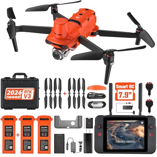
Autel Robotics EVO II Pro Enterprise RTK V3
The EVO II Pro Enterprise RTK V3 combines high-resolution imaging with onboard RTK positioning to provide accurate, survey-grade imagery and flexible payload options at a competitive price point, giving agronomists a balance of resolution and positional accuracy without the higher expense of some specialized survey platforms. In agricultural inspection contexts it is a strong mid-market choice for growers who want RTK precision and modular sensors (including thermal) but prefer a lower total cost than many full enterprise systems.
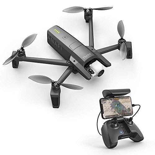
Parrot ANAFI USA
The ANAFI USA is a secure, rugged quadcopter that brings long optical zoom, thermal capability and hardened data encryption to field scouting, making it particularly useful for targeted inspections like pest hotspots, irrigation faults or infrastructure checks. It competes well on value for money in inspection workflows by offering powerful zoom and thermal sensors in a lightweight, easy-to-deploy package, though it does not match fixed-wing platforms for bulk-area efficiency.
AgEagle eBee GEO
The eBee GEO is a U.S.-focused fixed-wing mapping solution tailored for agricultural GIS integration and regulatory compliance, delivering reliable georeferenced mosaics and workflows optimized for farm management platforms. Its strength for agricultural inspection is the tight software and data pipeline for agronomic analysis, which can reduce post-processing time and overall service costs compared with more generic mapping drones.

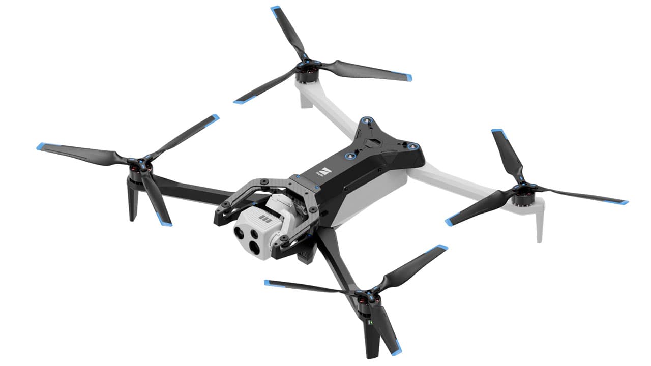
Skydio X10
The Skydio X10 leverages industry-leading autonomy and obstacle avoidance to perform persistent, close-proximity inspections in complex crop environments with minimal pilot intervention, reducing training and operational risk compared with manually flown platforms. For agricultural inspection use cases it is technically notable for automated flight paths and reliable obstacle negotiation—ideal for edge-of-field, orchard or greenhouse inspections—although its endurance and area-efficiency remain lower than fixed-wing survey leaders.
$14,000-25,000
Research-backed benefits and how they work
Multiple university trials, USDA field reports, and peer-reviewed studies demonstrate measurable benefits from routine aerial inspections and multispectral monitoring. Research shows that remote sensing indices such as NDVI and other vegetation indices detect plant stress, nutrient deficiency, and water stress earlier than visible symptoms. When drone data is integrated into field management, growers can target inputs more precisely, reduce chemical and fertilizer use, and in many cases improve yield or crop quality. Studies also document time savings for scouting and faster decision cycles that help limit pest or disease spread.
Early stress detection: Multispectral and thermal sensors identify water stress, nutrient deficiencies, and disease before symptoms are obvious on the ground.
Input optimization: Variable-rate prescriptions based on drone maps reduce fertilizer and pesticide use while maintaining or increasing yields.
Labor and time savings: Automated flights and fast image processing cut scouting time from days to hours for equivalent acreage.
Improved water management: High-resolution moisture and vigor maps guide targeted irrigation and conservation practices.
Return on investment: Field trials report faster payback periods when drone data is used to refine in-season decisions and reduce wasted inputs.
Scalable science: Results are replicated across university extension programs and NASA/USDA-supported remote sensing projects, making findings applicable to many crop systems.
Frequently Asked Questions
Which inspection drone should a large farm choose?
For very large farms, choose senseFly eBee X, since its long-endurance fixed-wing design is built for efficient hectare-per-flight coverage and centimeter-class photogrammetry for orthomosaic and DEM production (rating 4.5).
Does DJI Mavic 3 Multispectral support NDVI vegetation mapping?
Yes—DJI Mavic 3 Multispectral uses an integrated multispectral sensor array optimized for vegetation indices like NDVI, plus a high-resolution RGB camera for orthomosaics and automated repeatable field surveys (rating 4.6).
Is DJI Mavic 3 Multispectral cheaper than senseFly eBee X?
The provided data doesn’t include any prices for DJI Mavic 3 Multispectral or senseFly eBee X, so I can’t compare cost-to-value; it only lists ratings of 4.5 and 4.5 respectively.
Is senseFly eBee X compatible with LiDAR and multispectral payloads?
Yes—senseFly eBee X has modular payload compatibility, including RGB, multispectral, and LiDAR options, with RTK/PPK support for high-accuracy orthomosaics and DEMs (rating 4.5).
Conclusion
Agricultural inspection drones have become an essential tool for modern U.S. farming, and the seven models highlighted here cover a wide range of needs and budgets. The DJI Agras T40 brings heavy-duty agricultural capability for combined inspection and application tasks; the DJI Mavic 3 Multispectral excels at multispectral crop monitoring and is our best overall choice for crop inspection; senseFly eBee X and AgEagle eBee GEO are fixed-wing options for large-area mapping; the Autel Robotics EVO II Pro Enterprise RTK V3 offers high-resolution imaging with localization accuracy; the Parrot ANAFI USA is a rugged and portable choice for quick field checks; and the Skydio X10 adds advanced autonomy and obstacle avoidance for complex environments. We hope you found what you were looking for. If you want to refine or expand your search by sensor type, flight time, payload, or price, use the search or filters to narrow results and compare specifications.