

Best 3D Modeling Drones in the USA 2026: Top 7 for Surveying and Mapping
Published on Thursday, February 26, 2026
3D modeling drones capture comprehensive visuals that can be transformed into detailed three-dimensional models. In Cameras Camcorders > Camera Drones > Surveying Drones, these platforms combine high-resolution cameras, LiDAR or multispectral sensors, RTK/PPK positioning, and mapping software to produce reliable deliverables for construction, civil engineering, mining, archaeology, environmental monitoring, and real estate. In the USA market, demand is rising because businesses value faster site documentation, improved planning accuracy, lower field time, and safer inspections. Buyers tend to prioritize measurement accuracy, sensor flexibility (photogrammetry vs LiDAR), flight stability and autonomy, software ecosystem and integration, regulatory compliance such as FAA Part 107 workflows, and total cost of ownership including support and training. As a result, professional users and advanced prosumers choose drones that balance precision, ease of use, and scalable data processing for efficient 3D model generation.
Top Picks Summary
DJI Mavic 3 Cine
The DJI Mavic 3 Enterprise is a leading drone designed for professional use, especially in commercial applications. It features dual-camera capabilities, with a 4/3 CMOS Hasselblad camera that delivers stunning image quality and a telephoto lens for additional versatility. With advanced flight technologies and enhanced safety features, it provides reliable performance in various environments. Its longer flight time and extended range make it a top choice for surveying, mapping, and inspection tasks.

DJI Matrice 350 RTK
The Matrice 350 RTK is DJI's enterprise-grade platform and stands as the market leader for large-scale 3D modeling thanks to built-in RTK, long endurance, and modular payload compatibility that supports high-resolution RGB and LiDAR sensors. Compared with smaller prosumer models in this list it delivers superior georeferencing accuracy and faster survey turnarounds, which reduces field time and lowers per-project costs on complex mapping jobs. Its higher upfront price is offset by operational efficiency and flexibility that many customers find more cost-effective for repeated commercial modeling work.

Where to buy DJI Matrice 350 RTK in USA: the trusted retailers we track in this market, with the best price we have observed at each. Prices are checked regularly and can change, and the retailer confirms the final price at checkout.
We may earn a commission on purchases. It never affects our rankings.
$13,000 – $20,000
Autel Robotics EVO II Pro
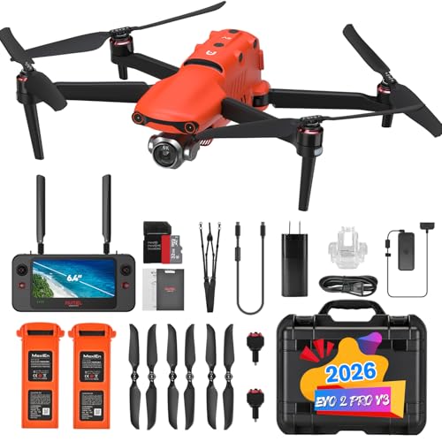
The EVO II Pro V3 balances high-resolution imaging and flight performance at a competitive price, making it a best-in-class choice for photogrammetry-focused 3D modeling teams that need excellent imagery without enterprise-level overhead. Against the Matrice 350 RTK and EVO Max 4T, it offers a lower acquisition cost while still producing dense, high-detail RGB datasets, though it typically lacks the built-in RTK and multisensor modularity of larger platforms. For projects where image quality per dollar is the priority, it provides strong ROI for small to mid-size modeling contracts.
Skydio X10
The Skydio X10 leads on autonomy and obstacle-aware flight, making it the top pick for intricate close-proximity 3D modeling around complex structures where manual piloting is risky or slow. Compared with the autopilot-light consumer drones here, X10’s advanced sensing and autonomous intelligence reduce operator skill requirements, increase safety, and can cut insurance and supervision costs on inspections and confined-site surveys. While its specialized autonomy can command a premium, the time savings and reduced re-flights often justify the investment for demanding architectural and industrial scans.

Where to buy Skydio X10 in USA: the trusted retailers we track in this market, with the best price we have observed at each. Prices are checked regularly and can change, and the retailer confirms the final price at checkout.
We may earn a commission on purchases. It never affects our rankings.
$10,000 – $14,000
Parrot Anafi USA
The Parrot Anafi AI offers a unique combination of AI features and high-quality imaging capabilities. This drone is equipped with a 32MP camera capable of capturing 4K HDR video, providing clarity and detail that professionals demand. Its lightweight design and foldable structure promote easy transport and setup, making it exceptionally user-friendly for outdoor projects. Additionally, the built-in AI capabilities allow for automated flight paths and intelligent data capture, enhancing the efficiency of aerial surveys or inspections.

DJI Air 3
The Air 3 is a compact, cost-effective prosumer platform that delivers strong RGB imaging for rapid, small-area 3D models and concept validation flights—an economical entry point for teams building photogrammetry workflows. It cannot match the RTK precision or payload versatility of enterprise units like the Matrice 350 RTK or EVO Max 4T, but its low price and portability make it ideal for quick site checks, preliminary surveys, and clients with tight budgets. For many small projects the Air 3 provides the best balance of image quality, convenience, and purchase cost.

Autel Robotics EVO Max 4T
The EVO Max 4T positions itself as an enterprise alternative optimized for inspection-led 3D modeling by combining multisensor payload options (including thermal) with rugged performance and advanced mapping workflows. Versus the Matrice 350 RTK it often undercuts on price while still delivering mission-specific sensors and integrated software for thermal overlays and fused datasets, offering a strong cost-to-capability ratio for infrastructure and public safety applications. Its strength is the ability to produce multi-layered models (RGB plus thermal) without the higher operational costs of larger, more modular platforms.

Why science and field studies support 3D modeling drones
Numerous industry tests and academic studies confirm that modern drone-based photogrammetry and airborne LiDAR deliver reliable spatial data when best practices are followed. Research and test reports emphasize accuracy gains from RTK/PPK positioning, the tradeoffs between photogrammetry and LiDAR under vegetation or complex geometry, and measurable productivity improvements on surveying and construction projects.
Accuracy: Peer-reviewed studies and industry validation tests show that drone photogrammetry with RTK/PPK and well-distributed ground control can achieve sub-decimeter to centimeter-level horizontal and vertical accuracy for many site types.
LiDAR vs photogrammetry: Research indicates LiDAR outperforms photogrammetry for penetrating vegetation and capturing under-canopy geometry, while photogrammetry excels at high-resolution texture and color detail for exposed surfaces.
Productivity gains: Field studies from construction and mining report reduced field time, faster volume calculations, and shorter project cycles when drones replace or supplement traditional survey methods.
Best practices: Studies stress the importance of mission planning, consistent overlap and camera settings, calibrated sensors, proper ground control or RTK workflows, and validated processing pipelines to reach published accuracy levels.
Safety and cost benefits: Case studies from utilities, bridges, and hazardous sites document improved worker safety and lower inspection costs when drones perform routine or dangerous surveys.
Frequently Asked Questions
Which drone should I buy for large-scale mapping?
For large-scale 3D modeling, consider the DJI Matrice 350 RTK, which includes built-in RTK for survey-grade positioning plus modular payload compatibility and long endurance up to ~55 minutes; it averages a 4.8 rating.
Does the Autel EVO II Pro V3 have a 1-inch sensor?
Yes—Autel Robotics EVO II Pro V3 uses a 1-inch high-resolution sensor with an adjustable aperture, and it’s rated 4.5 on average for photogrammetry-focused 3D modeling.
How does the pricing compare for Autel versus DJI?
Autel Robotics EVO II Pro V3 lists at $2,099.00 USDwhile the DJI Mavic 3 Enterprise lists at $2,099.00 USD; you also get ~40 minutes flight time on the Autel and up to 46 minutes on the Mavic 3 Enterprise.
Is the DJI Matrice 350 RTK rugged for field work?
The DJI Matrice 350 RTK has a rugged IP55 airframe with redundant flight systems, supports built-in RTK and dual-antenna GNSS, and averages a 4.8 rating.
Conclusion
3D modeling drones are transforming how American professionals collect spatial data and create accurate virtual representations. The seven top choices covered here — DJI Mavic 3 Enterprise, DJI Matrice 350 RTK, Autel Robotics EVO II Pro V3, Skydio X10, Parrot Anafi AI, DJI Air 3, and Autel Robotics EVO Max 4T — span entry-level prosumer options to full-featured industrial platforms. For most demanding surveying and mapping workflows, the DJI Matrice 350 RTK stands out as the best overall choice because of its modular payload options, reliable RTK/PPK support, and enterprise-grade reliability. We hope you found the comparison helpful. If you want to narrow results by budget, sensor type, or use case, or expand the list with more models, use the search to refine your selection.